Why use location services?
Nordic Semiconductor is a pioneer in battery-operated, ultra-low power wireless SoCs. While we are most well known for our Bluetooth Low Energy offering, our best-in-class nRF9160 SiP shares the same ultra-low power DNA. By using this innovative SiP with nRF Cloud Location Services, customers can extend the lifetime of their cellular IoT based products.
Location services are the cornerstone for devices being able to position themselves accurately, quickly and efficiently. By utilizing our single-cell (SCELL), multi-cell (MCELL), assisted GPS (A-GPS), predicted GPS (P-GPS) and/or Wi-Fi location features, customer's devices are guaranteed to last longer in the field, while sending accurate location data to the cloud.
Benefits of location services
|
|
Globally AvailableKnow where your assets are anywhere on the planet and at any time, whether it's for simple tracking purposes, remote management or offering additional services to your customers. |
|
|
Power efficientWe enable different location features that you can mix-and-match to find the right balance between accuracy and power consumption in your application at any given time. |
|
|
Usage flexibilityOur location services are extremely scalable and easy to integrate with back-end applications and various use-cases that best meet your application needs.
|
Multiple choices
For maximum flexibility
nRF Cloud Location Services can be used to assist devices and customer applications that need fast and power-efficient location details. They are designed specifically for Nordic silicon to enable high performing and ultra-low power consuming product solution. It includes A-GPS, P-GPS, SCELL, MCELL and Wi-Fi location features. More details about these features can be found in the nRF Cloud location services documentation.
These location features can all be implemented in the same device and used when needed, depending on the accuracy requirements at any given time. For example, if we want to track an asset moving between two locations, precise location is likely not needed while the asset is on route, as long as it can be determined that the asset is on the move towards the destination. That means that single-cell or multi-cell location should suffice, and that also ensures minimal power consumption. As the asset gets closer to the desired location it can enable GPS based location of even Wi-Fi if it's an urban area which is likely to have plenty of visible Wi-Fi networks, to determine a more precise location and track the asset all the way until it reaches its destination.
A-GPS and P-GPS
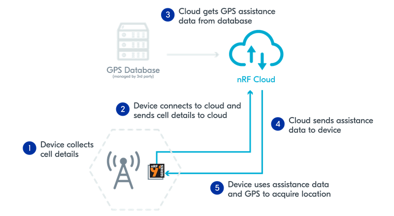
Regular GPS downloads assistance data via satellites (~50 bps). To speed things up, Nordic offers A-GPS and P-GPS which downloads the assistance data via LTE (~150 kbps). The data is provided in seconds instead of minutes via GPS.
A-GPS over LTE enables a download of new assistance data (e.g. ephemeris, almanac) via LTE. A quicker time-to-first-fix (TTFF) compared with regular GPS increases power savings.
P-GPS over LTE downloads a new asset plus up to two weeks of prediction data. The predictive assistance data can be valid up to 14 days. Some extra device processing helps provide valid assistance data available for periods without LTE coverage in remote areas. This useful feature also helps save on LTE costs vs cell-based location services.
SCELL and MCELL
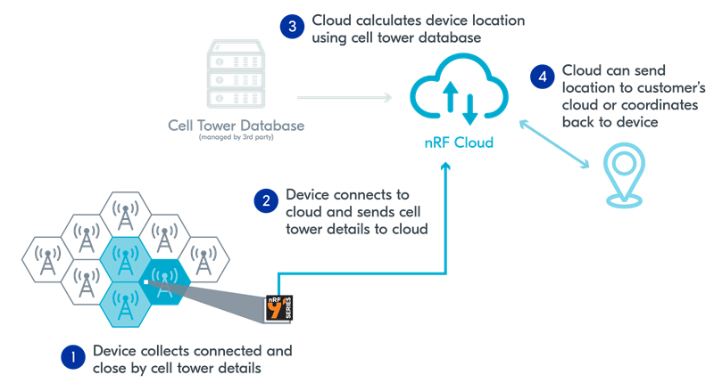
SCELL provides a power-efficient option to locate the device and consumes little power from the device. This is highly beneficial for indoor locations, no-power scenarios or crude location without requiring GPS.
MCELL: The main difference vs single-cell is using multiple cell towers to triangulate the device location. Up to 17 cell towers can be used at once.
Wi-Fi
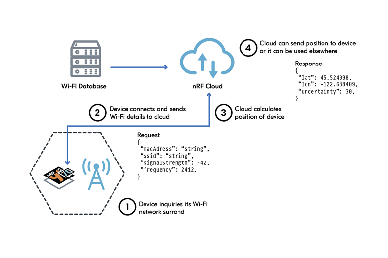
The device scans nearby Wi-Fi networks without connecting to them. It then receives Wi-Fi network details from at least two access points and then connects and sends the details to nRF Cloud. nRF Cloud then calculates the device position with help of a Wi-Fi database, which has coordinates of different Wi-Fi networks. The device position is then sent from nRF Cloud to either the customer cloud or back to the device. Our nRF70 Series of Wi-Fi companion ICs fits this use case well in combination with a nRF91 Series device. The nRF7000 is a dedicated IC made exactly for this use case. It supports active and passive Wi-Fi scanning.
Additional resources:
Location services comparison
| Location Feature | A-GPS | P-GPS | Wi-Fi | MCELL | SCELL |
|---|---|---|---|---|---|
| Accuracy (optimal) |
5 - 10 m |
5 - 10 m |
5 - 15 m |
200 - 300 m | 1000 m |
| Power Consumption |
High | High | Moderate | Low | Low |
|
Use case |
Precise outdoor position |
Precise outdoor position |
Which house/building |
Which neighbourhood |
Which city |
Real world example
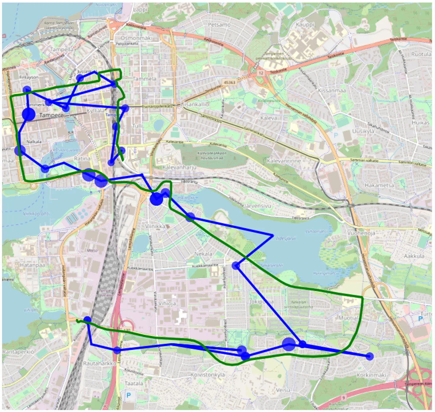
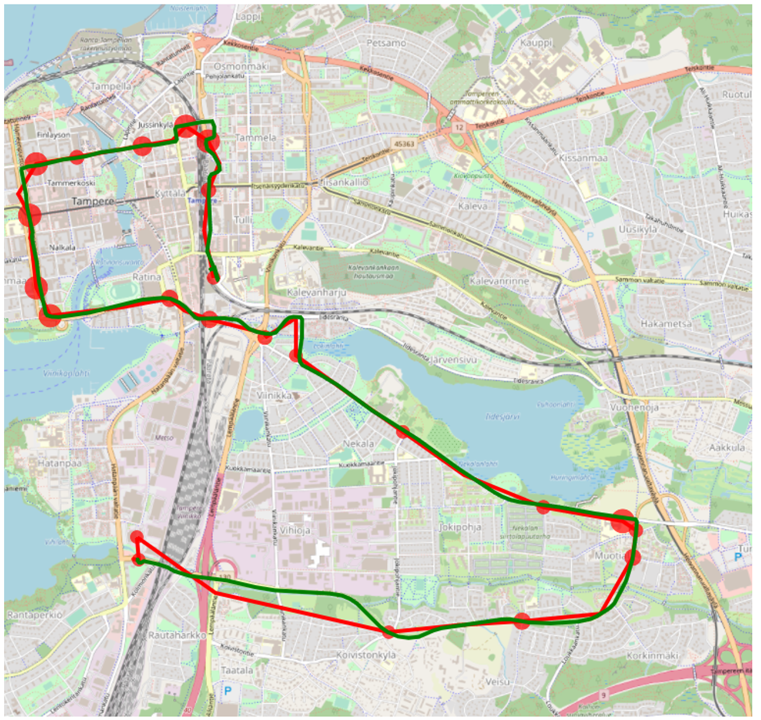
Through a field test
We took a test device out on a ride to get a real world benchmark between these location options. The GNSS tracked path can be considered the most accurate one (in green), and both cell (blue) and Wi-Fi (red) based location is shown.
As observed, the cell based location give us a more coarse location based off the nearest cell tower(s), while Wi-Fi provides an accuracy level much closer to GNSS in this type of urban environment.
GNSS vs CELL |
GNSS vs Wi-Fi |
 |
 |


